
Weiga Swamp lies in Butaleja District in Eastern Uganda, forming part of the Kyoga Basin’s complex wetland network. Its hydrological system connects to seasonal streams that drain into Lake Kyoga, serving as a natural regulator of floods and groundwater recharge.
The swamp’s papyrus cover stabilises soil and reduces sedimentation in nearby waterways, a process essential for sustaining downstream agricultural zones.
For generations, communities around the swamp have relied on it for fish, water, and papyrus.
These activities are not merely economic; they define social identity and cultural continuity. Local elders still recount how clan gatherings once took place along its edges, guided by traditional custodians who interpreted natural signs to forecast rainfall and fertility.
Today, Weiga faces increasing strain from land reclamation and agricultural expansion. The conversion of wetland edges into rice paddies has disrupted their seasonal water balance and reduced their natural filtration capacity.
Yet, amid these pressures, the swamp continues to demonstrate ecological resilience. Each rainy season, its floodplain revives, attracting herons, egrets, and migratory species that signal the health of Uganda’s interior wetlands.
The story of Weiga is one of continuity and caution: a living ecosystem balancing cultural heritage and human demand. It reminds us that Uganda’s wetlands are not remnants of wilderness; they are functioning landscapes sustaining people and nature together.
Geographical and Physical Context
Weiga Swamp is situated in Butaleja District in Eastern Uganda, within the broader Kyoga Basin catchment.
The swamp spans parts of Himutu, Mazimasa, and Kachonga sub-counties, intersecting rural settlements and small-scale farmlands.
Its approximate geographic coordinates are latitude 0°56′24.57″N and longitude 34°03′20.86″E, based on regional satellite data (GeoView).
Although often recorded as “Wega” or “Wiega” in specific reports, district-level land use maps from the Ministry of Water and Environment confirm that “Weiga” is the consistent local spelling.
No gazetted status has yet been assigned under Uganda’s Wetlands Inventory or Ramsar Framework.
Hydrology and Geomorphology
Weiga is a seasonal floodplain swamp fed primarily by rainfall and runoff from adjacent uplands.
During peak rains (April–May and September–November), the swamp’s water levels rise sharply, inundating low-lying areas and recharging adjacent aquifers.
There is no permanent inflow river. Instead, ephemeral streams collect surface runoff from rice fields and grasslands.
These drain into the swamp, which acts as a shallow inland basin. Gradual percolation into underground channels delays discharge into nearby streams, which eventually link to the Mpologoma River system.
Geomorphologically, the swamp rests on poorly drained alluvial soils with high organic content. Soil profiles exhibit seasonal saturation, with grey mottled clays in lower zones and papyrus peat accumulations in the core.
These conditions support anaerobic decomposition and nutrient retention, which are crucial for both ecological productivity and water purification.
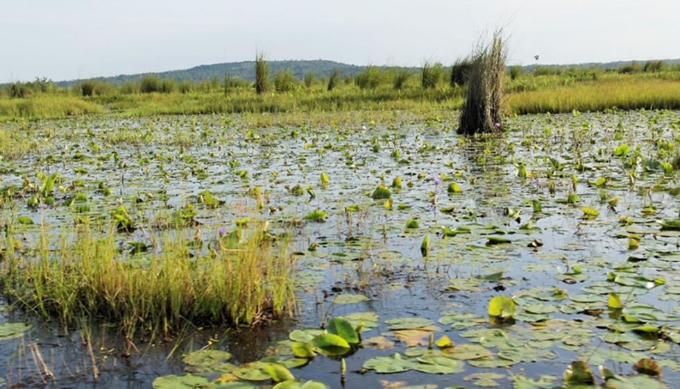
Land Cover and Seasonal Patterns
Vegetation cover is dominated by Cyperus papyrus, interspersed with patches of Vossia cuspidata and Ludwigia species. In drier months (December to February), the outer edges recede, exposing bare ground and encouraging temporary grazing.
During wet months, water depth increases to 0.3-0.8 metres. These conditions favour aquatic biodiversity and provide natural buffers against flash flooding.
Satellite imagery confirms annual fluctuations in swamp extent, typically expanding by 20–30% during peak rainfall.
Vegetation burning is occasionally observed at the fringes. This practice, often used to clear land for agriculture, disrupts regrowth cycles and contributes to biodiversity loss.
Current Environmental Condition
The swamp has undergone considerable pressure from land-use change.
Wetland boundary encroachment for rice farming, brickmaking, and smallholder settlements has led to fragmentation, especially along the western and northern margins.
No systematic hydrological monitoring station exists at the site.
However, aerial assessments from Uganda’s National Wetlands Atlas (Volume II) indicate a steady shrinkage in papyrus cover over the past decade. Ground truthing by community wetland users confirms this trend.
Despite these pressures, the central swamp core remains intact and functional.
It still supports seasonal water retention, natural filtration, and carbon sequestration, although these benefits are increasingly compromised.
Historical and Cultural Significance
Weiga Swamp has existed as a geographical anchor for communities in present-day Butaleja for centuries.
Oral accounts from elders in Mazimasa and Himutu suggest the swamp was once regarded as a buffer zone separating clan territories, with informal taboos governing who could exploit which section of the wetland.
The term “ekisoko,” used by some Iteso-speaking elders to refer to the swamp, denotes a sacred or restricted site, implying that ecological boundaries were historically tied to cultural governance.
Clan ceremonies were held near the inner wet zones during post-harvest periods. These gatherings often coincided with lunar cycles and rain rituals, particularly in years when rainfall patterns were delayed.
Senior custodians known as “abakungu” facilitated these rites, offering millet beer and animal blood to ancestral spirits believed to reside in the swamp’s heart.
These practices declined sharply after 1990 due to increased Christian evangelism, school expansion, and government enforcement of public health codes.
Papyrus and reed materials harvested from the swamp were integral to the construction of family huts, granaries, and burial shrouds.
Women led the weaving of mats and fish traps, embedding ecological knowledge into domestic economies.
During drought years, swamp-edge waterholes were considered fallback watering points for cattle, and fights occasionally broke out between herders competing for access.
The colonial administration altered perceptions of the swamp. British surveyors in the 1930s demarcated large portions of the surrounding grassland as crown land but paid little attention to the wetland itself. It remained a frontier zone until the 1970s, when government programs began promoting rice cultivation, leading to large-scale clearance of papyrus beds in exchange for subsidised seedlings.
Biodiversity and Ecosystem Services
Flora
The dominant vegetation cover in the swamp comprises the papyrus sedge (Cyperus papyrus), forming continuous stands across the core inundated zone.
Additional species include Vossia cuspidata in shallow water margins and emergent weeds such as Ludwigia spp. During draw‑down periods.
Soil surveys in Eastern Uganda’s seasonal wetlands document thick peat layers beneath papyrus stands, indicating accumulation of organic matter over decades.
These plant communities perform physical functions such as sediment trapping and water quality regulation. The dense root mats of papyrus slow surface flows, permitting suspended solids to settle.
During inundation, the water column depth (0.3–0.8 m) supports submerged vegetation and enables nutrient cycling via anaerobic peat decomposition.
Fauna
Although specific species inventories for the swamp are limited, general wetland research in Uganda indicates that such ecosystems support waterfowl, wading birds, amphibians, and fish adapted to seasonal flooding.
For instance, national wetland studies show that wetlands host high concentrations of bird species and provide breeding habitat.
In the swamp’s flood phase, the inundated papyrus provides roosting and hunting grounds for herons, egrets, and small wading birds.
The shallow water also supports fish whose life cycles depend on flood pulses, offering feeding opportunities for birds and possibly mammals.
Local fishing communities confirm seasonal increases in catch during inundation, which indirectly reflects ecological function.
The swamp edge is used by grazing livestock in dry months, indirectly supporting mammals such as marsh mongooses and small antelope.
Ecosystem Services
The swamp provides multiple ecosystem services with direct relevance to tourism and community livelihoods:
- Water filtration and purification: The wetland’s vegetation and soil matrix trap sediments and pollutants from agricultural runoff, improving downstream water quality. Uganda’s National Wetlands Policy explicitly recognises this function.
- Flood regulation: During heavy rains, the swamp absorbs excess surface water, reducing flood peaks in adjacent low-lying communities. This function aligns with studies that assign wetland systems a “shock‑absorber” role in hydrology.
- Carbon storage: Peat accumulation beneath papyrus beds serves as long-term carbon sequestration. Although specific measurements are lacking for Weiga, data from comparable East African wetlands indicate significant carbon stocks when flooding is maintained.
- Livelihood support: The wetland supplies fish, reeds for craft and housing, and grazing grass during dry seasons. These services contribute to sustainable tourism prospects, such as community-based bird‑watching or craft visits (should they be developed).
Visitor Experience and Tourism Potential
Weiga Swamp currently lacks formal tourism infrastructure.
However, its location, ecological features, and cultural context position it for low-volume, community-linked tourism aligned with Uganda’s broader ecotourism strategy.
1. Accessibility
- Nearest urban centre: Tororo (approx. 50 km southeast) or Mbale (approx. 60 km northeast)
- Road access: The swamp can be reached by feeder roads branching off the Tirinyi–Pallisa highway at Budaka, continuing through Himutu trading centre.
- Seasonal limitation: Road access becomes unreliable during April–May and October–November due to flooding. 4WD vehicles are recommended in wet months.
- Local transport: Boda‑bodas (motorcycle taxis) serve the last 5–10 km from the main road.
2. Potential Tourism Activities
- Birdwatching: The seasonal expansion of flood zones attracts waterfowl, including herons, egrets, and possibly the shoebill (Balaeniceps rex), though formal sightings remain unverified.
- Guided wetland walks: Dry-season papyrus clearings could host guided routes operated by trained local youth, focusing on ecology and cultural knowledge.
- Fishing observation: Visitors can observe seasonal fishing practices using traditional traps and nets during the swamp’s peak water periods.
- Cultural storytelling: Community elders may offer oral history sessions on swamp-related beliefs, seasonal rituals, and ancestral use patterns.
- Papyrus craft workshops: Local women’s groups already engaged in mat and basket weaving could demonstrate their techniques as part of participatory tourism.
3. Site Facilities and Hospitality
- Current status: No formal visitor centre, signage, or boardwalk infrastructure exists at Weiga Swamp. There are no marked trails, sanitation points, or shelters.
- Nearby accommodation: The closest formal lodging is in Budaka or Mbale Town. Homestay arrangements may be possible in Himutu or Mazimasa, but coordination would be required.
- Mobile coverage: Airtel and MTN signals are moderate near the swamp edge but weak in the deeper interior.
- Local coordination: Himutu sub-county office and village councils may assist with community liaison and visitor security arrangements.
4. Responsible Tourism Considerations
- Visitors should use certified local guides to reduce ecological disturbance and improve local earnings.
- Off-path movement in core swamp areas should be discouraged during the rainy season due to nesting grounds and fragile root mats.
- Community entry agreements and benefit-sharing structures need to be defined before formal product development.
- Operators should avoid plastic waste, disturbance of fishing zones, or invasive photography without consent.
5. Development Opportunities
- A community-based tourism model is best suited to Weiga’s ecological sensitivity and infrastructure limitations.
- Development should follow Uganda’s Wetlands Tourism Guidelines under the Ministry of Water and Environment, with phased upgrades beginning with signage and training.
- Linkage with existing East Uganda circuits (e.g., Sipi Falls, Tororo Rock, Nyero Rock Paintings) could position Weiga as a soft‑adventure or niche biodiversity extension.